Dec 4, 2013

Ensenada, Baja California

So, this is my last post  for this class. I really enjoyed doing it... Maybe I'll come back some day and post some other stuff.  For now this is what I got.  I wanted to let you know about this great place in Ensenada, Baja California (Mexico).  We visit the family often in Tijuana and many times we've taking a day trip to Ensenada to visit the "La Bufadora." It seems every time some who hasn't experience it up close, we get together and we take them there.  Yeah, I know, we could go somewhere else Rossy!! But that's the thing, if someone hasn't seen it, it's really a great experience.  Something about the grand ocean making this thunderous sound! I like it.  If you haven't experience it maybe you'll get the opportunity to do it!

Ensenada, Baja California

This beautiful city is located 70 miles South of the international Border (90 minutes drive from San Diego CA). Is Baja's third largest City; if you haven't been there, you should go. If you have, surely you'll enjoy a return visit.


La Bufadora is a marine geyser or blowhole located on the Punta Banda Peninsula in Baja California, Mexico. The spout of sea water is the result of air, trapped in a sea cave, exploding upwards. Air is forced into the cave by wave action and is released when the water recedes. This interaction not only creates the spout, but a thunderous noise as well. The phenomena repeats every minute or so with its volume depending on the strength of the waves.
La Bufadora is one of the largest blowholes in North America, often shooting upwards more than 30 meters (100 ft) above sea level. The exhibit hall roof top is approximately 24 meters (80 ft) above sea level and the blowhole frequently sprays above it.


La Bufadora (the blowhole) is about thirty minutes from Ensenada, in a seemingly remote section of Pacific coastline. If you drive through Ensenada, staying on the main road through town, you'll see signs to La Bufadora. Just follow the signs through the countryside dotted with farms and campgrounds, along the rugged coastline, up, around and down until you reach the end of the road. There are several shops & restaurants. Also, you will find three observation decks and plenty of steps and short walls to sit on, safe from the Pacific 'rain'. If you like to get into the thick of things, though, go to the middle observation deck and hang over the wall with everyone else. From there you can look down about 45 feet into what looks like a rock crevice about 10 feet wide. The crevice, however, is actually the mouth of a cave. As the waves recede from the cave it fills with air. When the waves come back in, the water entering the cave compresses the air until it explodes, blowing the water as high as 90 feet into the air.  How high the water shoots up depends on the tide conditions. You might wait five or six minutes between swells and if you're impatient you might give up and walk away just before the show starts.

I've been there many times, and every time is different! The day we went with my younger sister and her family was the best one we've seen regarding the blowhole.  That thing kept on going on for a long time and we were able to enjoy it.  And, yes, sometimes it doesn't want people to her the roar!! it just quiet.  I hope that when it's your first time you'll be able to see it in all its glory!
(I have lots of picture of my own, but I didn't have time to dig them out, Sorry!) Another thing to do in Ensenada is whale watching; during the months of January to March-April  is the best time.


I hope you like this one, short and simple! Until next time!
This is it folks!
 
Bea :)
 
References:
Kath, L. Price, P. (2011). Fun with the family - Southern California. Eighth Edition. Print


Dec 2, 2013

Novarupta Volcano

While I was doing my research for my blog I stumbled upon this information.  Professor Ron showed us a video on the eruption of Volcano Pinatubo in the Philippines and was very interesting.  After reading about Volcano Novarupta in Alaska I decided to share some of the information.
So here it is.   


June 6th, 1912
The morning of June 6th arrived on the Alaska peninsula to find the area which is now Katmai National Monument being shaken by numerous strong, shallow earthquakes. The most powerful volcanic eruption of the 20th Century was about to begin – but very few people knew about it. The Alaska peninsula has a low population density today, but in 1912 it was even lower. Beyond the land shaken by the earthquake activity, the beginnings of this event were almost unnoticed.


Volcanic Monitoring - 1912 vs. Today
 Today the stirring of an important volcano draws enormous global attention. Weeks or even months before most large eruptions, a buzz circulates through an electronically-connected community of volcano scientists as clusters of small earthquakes are detected by a global array of seismographs. Many scientists working at diverse global locations interpret this data and begin to collaborate about an awakening volcano and the eruption that might follow. Reports are posted on the internet and news stories communicate the volcano's activity to millions of people. Often it is a false alarm – the volcano is simply stirring.

If the earthquakes strengthen and begin moving upwards, many of these scientists will travel to the area of potential eruption to make observations and set up a local network of data-gathering instruments.

However, in 1912, Alaska was not a US state, very few scientists were supported to do volcanic studies and a worldwide network of seismic monitoring was not in place. Scientists were just starting to understand the mechanics of volcanic eruptions.

Novarupta Volcano Erupts!
 On June 6th, 1912 a tremendous blast sent a large cloud of ash skyward and the eruption of the century was underway. People in Juneau, Alaska, about 750 miles from the volcano, heard the sound of the blast – over one hour after it occurred.

For the next 60 hours the eruption sent tall dark columns of tephra and gas high into the atmosphere. By the time the eruption ended the surrounding land was devastated and about 30 cubic kilometers of ejecta blanketed the entire region. This is more ejecta than all of the other historic Alaska eruptions combined. It was also thirty times more than the 1980 eruption of Mount St. Helens and three times more than the 1991 eruption of Mount Pinatubo, the second largest in the 20th Century. 


Impact of the Eruption

The inhabitants of Kodiak, Alaska, on Kodiak Island, about 100 miles away, were among the first people to realize the severity of this eruption. The noise from the blast would have commanded their attention and the visual impact of seeing an ash cloud rise quickly to an elevation of 20 miles then drift towards them would have been terrifying.

Within just a few hours after the eruption a thick blanket of ash began falling upon the town - and ash continued falling for the next three days, covering the town up to one foot deep. The residents of Kodiak were forced to take shelter indoors. Many buildings collapsed from the weight of heavy ash on their roofs.

Outside, the ash made breathing difficult, stuck to moist eyes and completely blocked the light of the sun at midday. Any animal or person who was caught outside probably died from suffocation, blindness or an inability to find food and water. 


Pyroclastic Flow 
Back on the peninsula, heavy pyroclastic flows swept over 20 kilometers down the valley of Knife Creek and the upper Ukak River. (A pyroclastic flow is a mixture of superheated gas, dust, and ash that is heavier than the surrounding air and flows down the flank of the volcano with great speed and force.)

These flows completely filled the valley of Knife Creek with ash, converting it from a V-shaped valley into a broad flat plain. By the time the eruption was over, the world’s most extensive historic ignimbrite (solidified pyroclastic flow deposit) would be formed. It covered a surface area of over 120 square kilometers to depths of over 200 meters thick near its source. (The satellite image at right shows the original geographic extent of pyroclastic flow deposits as a yellow line.)


Volcanic Ash
Immediately after the June 6th blast, an ash cloud rose to an elevation of about 20 miles. It was then carried by the wind in a westerly direction, dropping ash as it moved. The ash deposits were thickest near the source of the eruption and decreased in thickness downwind.

When the eruption stopped on June 9th, the ash cloud had spread across southern Alaska, most of western Canada and several U.S. states. Winds then carried it across North America. It reached Africa on June 17th.

Although the eruption had these far-reaching effects, most people outside of Alaska did not know that a volcano had erupted. More surprising is that no one knew for sure which of the many volcanoes on the Alaska peninsula was responsible. Most assumed that Mount Katmai had erupted but they were wrong.      


Valley of Ten Thousand Smokes

 After the eruption, the National Geographic Society began sending expeditions to Alaska to survey the results of the eruption and to inventory the volcanoes of the Alaskan peninsula. Robert Griggs led four of these expeditions. During his 1916 expedition, Griggs and three others traveled inland to the eruption area. What they found exceeded their imagination.

First, the valley of Knife Creek was now barren, level and filled with a loose, sandy ash which was still hot at depth. Thousands of jets of steam were roaring from the ground. Griggs was so impressed that he called it the “Valley of 10,000 Smokes”.

James Hine, a zoologist on the expedition described the location:
“Having reached the summit of Katmai Pass, the Valley of Ten Thousand Smokes spreads out before one with no part of the view obstructed. My first thought was: We have reached the modern inferno. I was horrified, and yet, curiosity to see all at close range captivated me. Although sure that at almost every step I would sink beneath the earth's crust into a chasm intensely hot, I pushed on as soon as I found myself safely over a particularly dangerous-appearing area. I didn't like it, and yet I did.”

Katmai Caldera & Novarupta Dome

 
During the eruption a large amount of magma was drained from magma chambers below. The result was a removal of support from beneath Mount Katmai which is six miles from Novarupta. The top several hundred feet of Katmai - about one cubic mile of material - collapsed into a magma chamber below. This collapse produced a crater about two miles in diameter and over 800 feet deep.

Early investigators assumed that Katmai was responsible for the eruption. This assumption was based upon Katmai being near the center of the impact area, Katmai was visibly reduced in height, and early witness accounts thought that the eruption cloud ascended from the Katmai area. Closer observation was not possible and expeditions into the impact zone would be very difficult to accomplish.

The first scientific investigation to get an up-close look at the eruption area did not occur until 1916 when Robert Griggs found a 2-mile-wide caldera where Mount Katmai once stood. He also found a lava dome at the Novarupta vent. These observations convinced Griggs that Katmai was the source of the eruption.

It was not until the 1950s - over forty years after the eruption - that investigators finally realized that ash and pyroclastic flow thicknesses were greatest in the Novarupta area. This discovery produced a revelation that Novarupta - and not Katmai - was the volcano responsible for the eruption. This is possibly the most important false accusation in the history of volcanic study.  


Well I hope you enjoyed it!  This is it for now folks!
Bea :)

References:
www.geology.com
Tarbuck, E.J., Lutgens, F.K., (2011). Earth- An introduction to physical geology. Print


Nov 30, 2013

Diamonds

Did someone said "Diamonds".. Hey I'm a girl I got to love diamonds! In actuality, I changed my mind after I watched the movie "Blood Diamonds"... But here we are going to talk about how the diamonds are form. So, How do diamonds form?.. Contrary to what many people believe, most diamonds do not form from coal.

Coal has rarely played a role in the formation of diamonds.  In fact, most diamonds that have been dated are much older than Earth's first land plants - the source materials of coal! That alone should be enough evidence to shut down the idea that Earth's diamonds deposits were formed from coal.

Another problem with the idea is that coal seams are sedimentary rocks that usually occur as horizontal rock units.  However, the source rocks of diamonds are vertical pipes filled with igneous rocks.

Four processes are thought to be responsible for virtually all of the natural diamonds that have been found at or near Earth's surface. One of these processes  accounts for nearly 100% of all diamonds that have ever been mined.  The remaining three are insignificant sources of commercial diamonds.

These process rarely involve coal
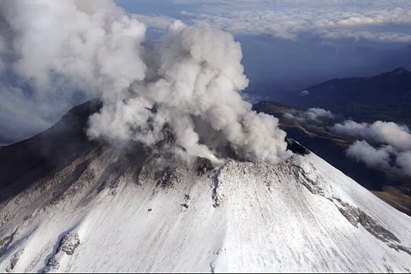
1) Diamonds formation in Earth's Mantle.
Geologist believe that the diamonds in all of Earths commercial diamond deposits were formed in the mantle and delivered to the surface by deep-source volcanic eruptions. The formation of natural diamonds requires very high temperatures and pressures. This conditions occur in limited zones of Earth's mantle about 90 miles (150 kilometers) below the surface where temperatures are at least 2000 degrees Fahrenheit (1050 degrees Celsius).


2) Diamond formation at impact zones:

Tiny diamonds have been found in rocks that are thought to have been subducted deep into the mantle by plate tectonic process- then returned to the surface. Diamond formation in a subducting plate might occur as little as 50 miles (80 kilometers) below the surface and at temperatures  as low as 390 degrees Fahrenheit (200 degrees Centigrade).  In another study, diamonds from Brazil were found to contain tiny mineral inclusions consistent with mineralogy of oceanic crust.


Is coal involved?  Coal is a sedimentary rock, formed from plant debris deposited at Earth's surface. It is rarely buried to depths greater than two miles (3.2 kilometers). It is very unlikely that coal has been moved from the crust down to a depth well below the base of a continental plate. The carbon source for these mantle diamonds is most likely carbon trapped in Earth's interior at the time of the planet's formation. 
3) Diamond Formation at Impact Sites

Throughout its history, Earth has been repeatedly hit by large asteroids. When these asteroids strike the earth extreme temperatures and pressures are produced. For example: when a six mile (10 kilometer) wide asteroid strikes the earth, it can be traveling at up to 9 to 12 miles per second (15 to 20 kilometers per second). Upon impact this hypervelocity object would produce an energy burst equivalent to millions of nuclear weapons and temperatures hotter than the sun's surface (5).

The high temperature and pressure conditions of such an impact are more than adequate to form diamonds. This theory of diamond formation has been supported by the discovery of tiny diamonds around several asteroid impact sites. See Location 3 in the diagrams above and at right.

Tiny, sub-millimeter diamonds have been found at Meteor Crater in Arizona. Polycrystalline industrial diamonds up to 13 millimeters in size have been mined at the Popigai Crater in northern Siberia, Russia.

Is coal involved? Coal could be present in the target area of these impacts and could serve as the carbon source of the diamonds. Limestones, marbles, dolomites and other carbon-bearing rocks are also potential carbon sources.
 
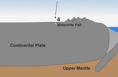
4) Formation in Space

NASA researchers have detected large numbers of nanodiamonds in some meteorites (nanodiamonds are diamonds that are a few nanometers - billionths of a meter in diameter). About three percent of the carbon in these meteorites is contained in the form of nanodiamonds. These diamonds are too small for use as gems or industrial abrasives, however, they are a source of diamond material (6), See Location 4 in the diagrams above and at right.

Smithsonian researchers also found large numbers of tiny diamonds when they were cutting a sample from the Allen Hills meteorite (7). These diamonds in meteorites are thought to have formed in space through high speed collisions similar to how diamonds form on Earth at impact sites.

Is coal involved? Coal is not involved in the creation of these diamonds. The carbon source is from a body other than Earth.


The Most Convincing Evidence

The most convincing evidence that coal did not play a role in the formation of most diamonds is a comparison between the age of Earth's diamonds and the age of the earliest land plants.

Almost every diamond that has been dated formed during the Precambrian Eon - the span of time between Earth's formation (about 4,600 million years ago) and the start of the Cambrian Period (about 542 million years ago). In contrast, the earliest land plants did not appear on Earth until about 450 million years ago - nearly 100 million years after the formation of virtually all of Earth's natural diamonds.

Since coal is formed from terrestrial plant debris and the oldest land plants are younger than almost every diamond that has ever been dated, it is easy to conclude that coal did not play a significant role in the formation of Earth's diamonds.
Well, that's it on these diamond, and what do you think about this:

According to CBS News:
It may sound a bit dark, but it’s now possible to transform the ashes of the cremated deceased into a diamond–a jewel truly to remember.
Using “Russian technology,” Algordanza Memorial Diamonds are created in a similar fashion to the way natural diamonds are formed.

Here’s how it works: a diamond is composed of pressurized carbons. Conveniently enough, human bodies are about 18 percent carbon. Using about a pound of ashes, the company is able to distill out the carbon and use it to form a man-made diamond in a mold under high pressure in about a week. These synthetic diamonds created this way are often blue because of certain chemicals in the human body.
Algordanza, headquartered in Switzerland, offers a variety of diamond sizes and cuts that can be placed on a ring or other jewelry pieces. Prices run higher than conventional diamonds, starting from about $3,000 depending on the size and cut.
The resulting diamond will be “an everlasting keepsake, remembrance, or heirloom to pass to future generations,” Frank Ripka, CTO of Algordanza, told BusinessInsider.
LifeGem, based in Elk Grove Village, Ill.,  calls itself the original inventor and says it holds the U.S. patent for memorial diamonds. In a year, the company has “generally about a thousand customers worldwide,” a spokesperson from LifeGem told ABCNews.com.
LifeGem’s popular products, the company says, include the colorless LifeGem because it looks like the diamonds to which the public is accustomed. Blue diamonds are also in demand, the company says, because it is “difficult to get a blue diamond from nature.”

Diamond prices have fluctuated in recent years. From 2011 through 2012, overall prices for rough and polished diamonds declined by 14 percent and 13 percent, respectively, according to Bain & Company’s Global Diamond Report 2013.
Could synthetic Memorial diamonds be more worth than a natural diamond because of their sentimental value? Or is it a macabre product?

My answer, Not sure.  What is yours?


Sample.
 
 
This is it folks, till next time.

Bea :)

Sources:
www.geologynews.org
www.cbsnews.com

Nov 28, 2013

California Geology

Since we live in California I decided to do a little research regarding California's Geology.  It's actually pretty interesting.  I think that's the reason why my professor (Dr. Ron) decided to move here.  Some many different geologic events/stuff to see, besides, he is in love with Geology!

Last time I talked about the San Andreas Fault and I stumble upon the rest of this information:

Thanks to the San Andreas Fault, and in large sense plate tectonics, California is one of the most geologically complex places in the world.  The state contains may major tectonic features:

Plate boundary :      San Andreas Fault
Triple junction:       Mendocino Triple Junction
Spreading center:     Brawley Siesmic Zone
Subduction zone:     Cascadia Subduction zone
Active volcano:       Mt. Lesssen and Mt. Shasta
Hot spot:                  Long Valley, Clear Lake Volcanic Field, and others.

 
California is a land of extremes, and extreme beauty.  The highest and lowest points in the continental US are in California and are only seventy five miles apart: Mt. Whitney and Death Valley.  Such topographic extremes can only come from tectonics and are short-lived, geologically speaking.  The largest food-producing valley in the world is the San Joaquin Valley, providing 1/8th of nation's food.  California has more climate zones than any other state.
 
California's vast geographic and climatic character is also due to tectonics.  The Sierra Nevada create uplift of moist oceanic air masses and it rains. Much of the water reaches the San Joaquin valley but by the time the storms reach the eastern Sierra and Owens Valley, most of the water has been wring form the clouds.  The White and Inyo mountains, only twenty five miles east of the Sierra Crest, are semi-arid.  They suck the remaining water form the skies and by the time the air reaches the Saline and Death Valleys, it is bone dry.  Such weather patters have a great influence on the surface geology as well: erosion, deposition and chemical alteration take place rapidly in many parts of California.


Another reason California is so geologically-diverse is because it is big.  The bigger the state, the more likely it is to encompass interesting geology.  Only Alaska is larger and more varied, and it is four times larger than California.  Both states have eight National Parks- more than any other states- and the parks are draped over some of the most spectacular geological scenery in the world.  Like California, Alaska is a tectonically active region.
 
California's state rock, mineral and gem are all products of tectonics: serpentine, gold and benitoite.
 
Watering Cove Abel Tasman National Park

Half Dome - Yosemite Valley


Yosemite Half Dome:
Looking a bit like half an ice cream scoop awaiting the next bite, Half Dome is an iconic landforms in Yosemite National Park (nps.gov). At one time the mountain, with its near vertical granite face, was considered inaccessible. Yet today it is one of the most challenging climbs in the park. Those who make it to the top of the near 5,000-foot high landform are rewarded with a view of Yosemite Valley and a good portion of the Sierra Mountains. The park service has laid out trails and installed cables to help climbers reach the summit. Other than that, Half Dome remains in its natural state.

Glacier Point - Yosemite National Park
 
Death Valley:
Death Valley is a place of extremes. In summer, temperatures can get above 120 degrees Fahrenheit and stay there. During the winter, mountains rimming the canyon can have a dusting of snow on their peaks. Death Valley was created by the shifting of the earth's crust in earthquake-prone California. At 282 feet below sea level, Death Valley is the lowest bit of land in North America. It sits between two mountain ranges, the Panamint Range to the west and the Amargosa Range on the valley's east end. Borax commercials featuring the legendary 20 mule teams that hauled the raw borax ore across this desert made Death Valley a well-known name. Today, Death Valley National Park (nps.gov) attracts visitors wanting to explore this challenging environment. Sand dunes, salt flats and Salt Creek, home to the endangered pupfish, are all part of the experience.


Lake Tahoe:
California shares Lake Tahoe, located in the Sierra Nevada mountains, with the state of Nevada, but two-thirds of the lake is inside the California border. Created by active fault lines, the lake's surface sits 6,225 feet above sea level. The surrounding mountains have peaks that reach some 10,000 feet in height. At a maximum depth of 1,645 feet, Lake Tahoe is considered one of the United States' deepest lakes. In winter skiers flock to the various ski-hills that rim the lake. During the summer, camping, boating and fishing are the big attractions. Of course, the Nevada side offers year-round gambling, which is illegal on the California side of the lake. Cal Neva Resort (calnevaresort.com) gets around this rule by sitting on the state line. Walk to the Nevada side and roll the dice.
 

Beautiful Country, but gorgeous State...

This is it folks!  Till next time

Bea :)

References:
www.sanandreasfault.org
Tarbuck, E.J., Lutgens, F.K., (2011). Earth- An introduction to physical geology. Print


Nov 25, 2013

San Andreas Fault

 
Wait, whose fault is it?.... Not mine, I didn't do it! Who then? Ah... It was Mother Nature. She decided to give California a fault. So what's a fault?.... let me explain.
A fault is a planar crack in a rock along hitch slippage has taken place. Most faults are small - even microscopic - and are not important. Some faults are many miles long. (Sanandreasfsult.org)
Recently we went on a filed trip with Professor Ron. It was really interesting to see the fault in person.


This was one of our first stops. - Soda lake!... Not Pepsi thou! I was thirsty!
We had beautiful weather.

Our next stop was carrion plane.. (Now I know what Tia Fina was talking about!... Tia Fina likes walking through nature a lot!


When we got on top of the hill the wind was very strong!
 
 
Then we got Wallace Creek. (Funny my princial's last name is Wallace... Is this your creek Wallace? Naah! I didn't think so).


(Cutie pie!!).. The baby!


And finally we got to the fault. Ok, I'm impress mothe nature! But did you really had to give it to California... Why not Timbuktu, I'm just saying.. 

Professor Ron pointed out that the labels on the plate tectonics were incorrect. I had no idea because some times even though I'm not Chinese, I get disoriented!! (Inside joke).. The truth is that being at the fault you can jump from one plate to another! (North Plate and Pacific Plate) because the fault is in the middle. Pretty interesting stuff.

So, ladies and gentlemen this is it. San Andreas Fault.


Pacific Plate/ North Plate..?! I'm still disoriented, maybe you can figure it out.

Some scholarly info: 
The SAF is a place where two tectonic plates touch, the North Amrican and the Pacific Plate (I told you!:). The plates are rigid (or almost rigid) slabs of rock that comprise the crust and the upper mantle of the earth. The SAF is about 700 miles long when it's curves are measured. It is roughly ten miles deep, and I raches from the Salton Sea in Imperial county to Cape Mendocino in Humboldt county.

The plates are continually moving but where they touch each other, they get stuck. As the rest of the plate moves, the stuck parts deform like compressing spring so they built up stress in the rocks along the fault.  When the rock breaks or slips the suddenly plates the suddenly plates move, causing an earthquake.
 
So, there was a question I was itching to ask.. What's going to happen when we we get "The Big One"... Is it going to split open and everyone will fall over? Is the pacific plate goin to go to the sea leaving a big gap and become a brand new island?  Well, the answer to all these questions is NO...

The SAF is about 25 millions years old.  The grinding plates and earthquakes are gradually warping and reshaping California.  In a few millions years, California will look very different than it does today!.. and I don't think we'll be around that long!

Well this is it folks, hope you enjoy it!

Bea :)

Sources:

www.sanadreasfault.org
Tarkbuck, E., Lutgens, F. (2011). Earth- An introduction to physical geology. Pearson. Print.
 

Nov 1, 2013

Fracking


Fracking

Whaaat?... what is it?.... That's what I said when I heard this word for the first time.  A teacher from the school I work at was helping me out by giving me ideas on themes for my blog, and she told me that recently on the news there was something about "Fracking" in Texas. So I told her that I was going to look into it and maybe make it a blog.
 
Let me start by the definition, until now I hadn't hear that word before.
 
Hydraulic Fracturing: In some shale deposits.  there are significant reserves of natural gas that cannot naturally leave because of the rock's low permeability.  The practice of hydraulic fracturing (often called "fracking") shatters the shale, opening up cracks through  which the natural gas can flow into wells and then be brought to the surface.  The fracturing of the shale is initiated by pumping fluids into the rock at very high pressures.  The fluid is mostly water but also includes other chemicals that aid in the fracturing process.  Some of this chemicals may be toxic, and there are concerns about fracking fluid leaking into aquifers that supply people with freshwater.  The injection fluid also includes sand , so once fractures open up in the shale, the sand grains can keep the m propped open and permit the gas to continue to flow.  Once the fracture has been accomplished, the fracking fluid is brought back to the surface.  This wastewater is then injected into deep disposal wells.  In some locations, these injections appear to trigger numerous minor earthquakes. (Tarbuck,  p. 786)

New Research on surface Spills in Fracking Industry
The fracking industry has created many concerns about potential safety and environmental effects of the process, including possible groundwater contamination.  To better understand gas extraction through hydraulic fracturing, health scientist Heather Avens and colleagues researched surface spills caused by fracking.  Their research examined data between July1 2010, and July 2, 2011,  from the Colorado Oil and Gas Conservation Commission and addressed potential contamination from benzene, toluene, ethylbenzene and xylene (BTEX).

At the 2013 American Industrial Hygiene Conference and Expo in Montreal, Quebec, Avens shared these key findings:
 * Seventy seven surface spills that affected groundwater were recorded in Weld County, where 18,000 wells were active.
 *Surface spills were experienced at about 0.4% of active wells
 *An average of seven barrels of hydraulic fracturing water was spilled during each incident.
 *The average area of spill was 197 cubic meters and the average depth was 2m.
 *Tank battery systems represented a major point of origin for spills.
 * Spills were most often caused by equipment failure.
 * BTEX concentration were significantly lower outside the excavation area than within the excavated area and decreased rapidly as the distance from a spill increased.

Besides general regulations covering oil and gas operations that happen to include fracking, a wave of fracking-specific laws and regulations have swept the nation over the last four years or so. Four key areas where the regulations of the states have had an impact on fracking operations are: (a) control of the acquisition and use of water for fracking; (b) disclosure of chemicals used in fracking fluid; (c) flow back water disposal requirements; and (d) requirements for casing, cementing, drilling, and completion. An additional emerging issue is the promulgation of surface use limitations, either by local governments or at the state level.            


In recent news, fracking has had negative consequences in society like the case of Texas.
 
The people of West Texas are literally praying for rain.  The region has experienced heavy droughts in recent years. Despite the droughts, however, Texas is famous for denying the science behind things like climate change and evolution, and also for voting over and over to de-regulate the oil and the gas companies that are consuming the area's water supply with fracking.
 
People are concern because they are running out of water.  "Despite those prayers, however, Texas has suffered years of sustained drought.  On top of that, the oil and gas industry's demand for water used in fracking are running down reservoirs and aquifers, and contaminating whatever's left.  Rapidly-increasing climate change is working against Texas' cattle industry, as well making things even worse for the people of West Texas towns like Barnhart, and any other towns in Briscoe, Burnet, or Comal counties." (Clean Technica)
 
In order to alleviate the negative impact of fracking on society, many researchers suggest the following recommendations:
  1)Well operators should conduct comprehensive chemical risk analyses to better understand surface spills.
 2) Water table depth and other factors should be carefully considered.
 3) Equipment safety systems should be examined and enhanced as needed, especially for sties where human attendants are not consistently present.
 4)Well operators must effectively communicate safety procedures and risks.
 
 
References:
 
Tarbuck, E.D, Lutgens, F. 2011. Earth an Introduction to Physical Geology. 11th Edition.
Saefety Matters. Retrieved October 2013 from http://goo.gll/qJdmq.
Clean Technica. Fracking update: These are the Texas towns running out of water. October 2013 
Schumacher, J. Texas Review of Law & Politics. Spring2013, Vol. 17 Issue 2, p239-303. 65p.


Meteors

Meteors

So, I don't know about you, but there are some things we don't even think about in our daily life, even when we know they exist and we might not have the faint idea that they could be dangerous.  I'm talking about meteors.  When we stop and look at the sky at night time and we see the stars we can't help to think how grand it is, and often times we dismiss the fact that we are exposed to being wiped out just like the dinosaurs.  It turns out that last month a meteor passed so close to earth that NASA was a bit concern.  Whaaat?... and no one told me.  I guess if that meteor had hit Earth maybe we've all been gone!! But, not this time, we're still here.  I guess I have to make time to watch the news every now and then to see what's going on.  I don't want to be like the dinosaurs and don't know what hit them.  Lets see what happens in 19 years when this meteor is scheduled to come back... I better tell my grandkids!!
 
Let me tell you some things about meteors.  Many of you may know all this but just in case.
 
 
According to Geology.com:
Ever since the Earth formed about 4.5 billion years ago, it has been bombarded with rocks from space.  Each year about 50,000 tons of asteroidal material enters the Earth's atmosphere.  Most of it burns up high in the ionosphere due to friction with air.  But a few rocks get through.
 
Large space rocks are called asteroids, and small ones are called meteoroids.  When they streak through the atmosphere they are called meteors, or "shooting stars" if the reach the ground they are called meteorites.
 
What are they made out of?
Most asteroids and meteorites are composed of rocks similar to those on Earth - olivine, pyroxene, etc.  This are called "chondrites" or "stones".  Stones that are rich in carbon are called "carbonaceous chondrites" and some of these contain amino acids, the building blocks of life.  Some astronomers believe that life on Earth was seeded by comets and meteorites.
 
Comets are much less common than asteroids, but one in while they strike the Earth too.  Comets are irregular balls of dusty ice- "dirty snowballs"- a few km across.  They are largely inert except when they are heated as they pass near the sun an release gas and dust to form their tails.
 
How often do they hit the Earth?
Every day! but only rarely does one reach the ground.  Depending on their composition, meteors smaller than about 10 m in diameter do not survive their passage through the atmosphere.  A smaller iron would probably make it through but it would take a larger comet to survive our atmosphere.


Recent News

According to CNN:
 
One of the most dangerous asteroids or record zipped close by Earth last month.  It made headlines on Thursday, when reports said that there's a chance it could strike our planet in less than 20 years.  Such a collision could unleash a force as powerful as a couple of thousand atomic bombs.
 
But NASA was quick to calm nerves and point our some very good news.  The most dangerous known asteroids don't really pose much of a threat.  And there are very few of them.
 
According to NASA:
Newly discovered asteroid 2013 TV135 made close approach to Earth on Sept. 16 when it came within about 4.2 million miles (6.7 million kilometers).  The asteroid is initially estimated to be about 1,300 feet (400 meters) in size and its orbit carries it as far out as about three quarters of the distance to Jupiter's orbit and as close to the sun as the Earth's orbit.  It was discovered on October 8, 2013, by astronomers working at the Crimean Astrophysical Observatory in the Ukraine.  As Oct. 14, asteroid 2013 TV 135 is one of 10,332 Near-Earth objects that have been discovered.
 
With only a week of observation for an orbital period that span almost 4 years its future orbital path is still quite uncertain, but this asteroid could be back in the Earth's neighborhood in 2032.  However, the Near-Earth Program Office states the probability this asteroid could then impact Earth is only 1-in 63,000.  The object should be easily observable in the coming months and once additional observations are provide to the Minor Planet Center in Cambridge Massachusetts, the initial orbit calculations will be improved an the  most likely result will be a dramatic reduction, or complete elimination, of any risk of Earth impact.
 
"To put it in another way, that puts the current probability of no impact in 2032 at about 99.998 percent," said Don Yeomans, manager of NASA's Near Earth Object Program Office at the Jet Propulsion Laboratory in Pasadena, Calif. "This is a relatively new discovery.  With more observations, I fully expect we will be able to significantly reduce, or rule out entirely, any impact probability for the foreseeable future."
 
NASA detects, tracks and characterizes asteroids and comets passing close to Earth using both ground- and space-based telescopes.  The Near Earth Object Observation Program, commonly called "Spaceguard." discovers these objects, characterizes a subset of them, and determines their orbits to determine if any could be potentially hazardous to our planet.
 
Wow! how interesting.  This leaves me with a sense of security, to know that someone is really watching out for Earth. I guess my trouble will be finding out when something is going to happen. Many people find things out on FaceBook (I don't have a Face Book!.... Vero, you better let me know if something is going on!). I should start watching the news once in a while.

Ok, this is it for now folks! I leave you with nice pictures of comets and meteors.

B :)